
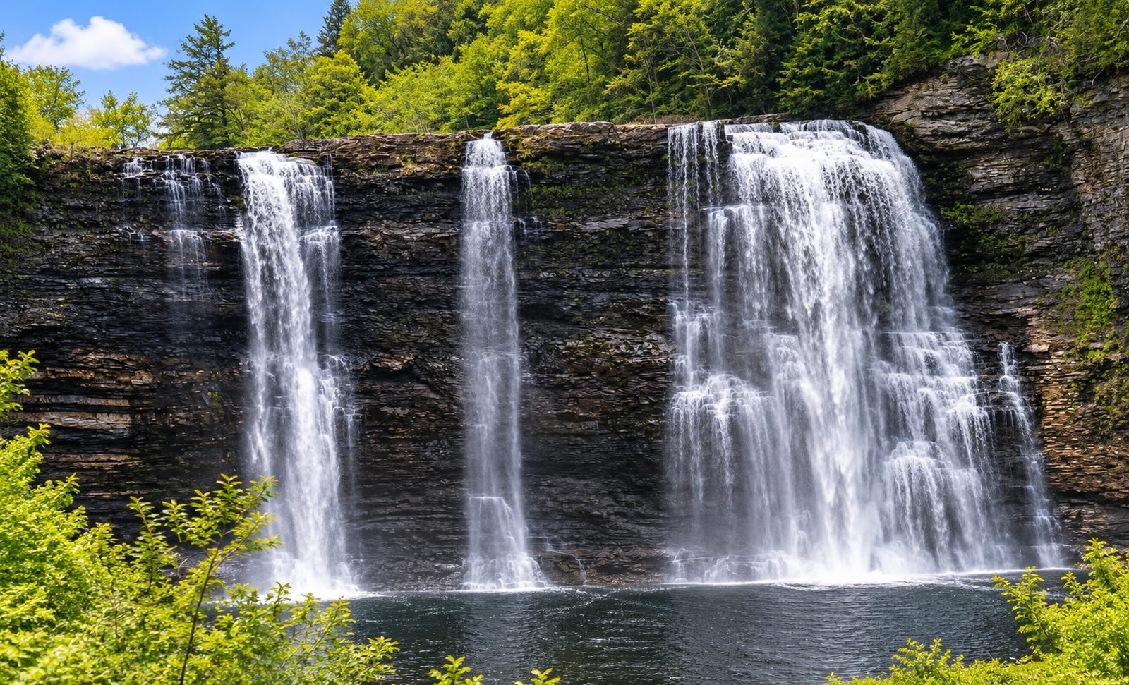
Northern New York is waterfall country, though it doesn’t advertise the fact. The same geology that built Tug Hill and the Adirondack foothills — hard rock, steep little rivers, and a great deal of moving water — has cut falls all across Jefferson, Lewis, and St. Lawrence counties: a 110-foot curtain on the Salmon River, seven falls along a single back road in the Grass River Wild Forest, a town-park falls in Martinsburg, and the old mill falls on the Black River in Watertown itself.
This guide covers the falls a reader can actually go and see — every entry below has public access or a legitimate public viewpoint, verified against the land managers and the county guides. A few famous names are missing on purpose: a falls on posted private land with no public view isn’t a destination, it’s a disappointment, and we’d rather tell you that here than have you learn it at a no-trespassing sign.
When to go: as a general rule, North Country falls run hardest with spring snowmelt (April into May) and after sustained rain, and some shrink to a trickle in a dry August. Fall color is the second season — the water may be lower, but a maple gorge in mid-October is its own reward. Two cautions apply everywhere below: rocks near falling water are slick in every season, and gorge rims and cliff edges deserve real respect, especially with children.
On this page
- Jefferson County falls
- Lewis County falls
- St. Lawrence County falls
- The Tooley Pond Road waterfall drive
- Just beyond the line
- Before you go
- Frequently asked questions
- Waterfall map
Jefferson County falls
Jefferson County’s falls are mostly Black River falls — the river that powered Watertown’s mills drops through the city and its villages in a series of dams and ledges, most of them viewable from public streets and lots.
Great Falls — Watertown
Location: Black River, off Mill Street, Watertown · Access: Roadside — viewable from the parking lot near the bridge · Source: nnywaterfalls.com
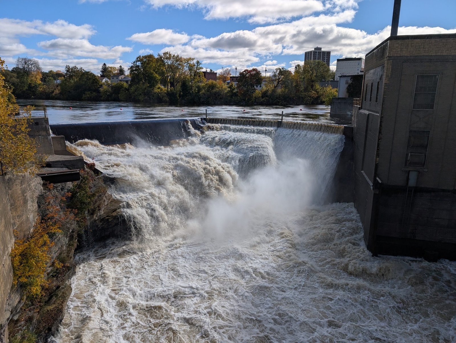
The falls that built a city. Great Falls — also called Black River Falls or Watertown Falls, with Great Falls the widely used name — is the historic mill falls of Watertown, where water power on the Black River drew the industry that became the city. A later power dam capitalized on the same drop. Today it’s the easiest falls in this guide to see: park in the lot near the bridge off Mill Street and the river is in front of you.
Burrville Cider Mill Falls — Watertown
Location: Jacobs Creek, at the Burrville Cider Mill, 18176 Co. Rt. 156, Watertown · Access: Viewing platform on mill grounds · Season: Mill open Labor Day–Thanksgiving, daily 9 a.m.–7 p.m. · Source: Burrville Cider Mill
The falls beside the Burrville Cider Mill — a Jefferson County landmark — are viewed from a wooden platform a short walk from the mill’s parking lot. The catch is built into the charm: the mill is a fall business (open Labor Day to Thanksgiving, and 2026 is its 50th season), the falls are on its land, and the mill advises against winter visits because of snow and ice. Plan this one as part of a cider-mill trip in the fall — which is how most of the county has always seen it.
Long Falls — Carthage
Location: Black River, village of Carthage · Access: Roadside — streetside or paved-lot parking · Source: nnywaterfalls.com
Long Falls earned its name honestly: the drop spans the Black River between Carthage and West Carthage. What you see today is a working hydroelectric project — a dam falls in the middle of a village, viewed from the street. It’s not a wilderness stop, but as a drive-through look at the river that powered the twin villages, it’s a genuine one.
Totman Falls — Lorraine
Location: Totman Gulf, off Lemay Road, Lorraine (Jefferson County forestland) · Access: Public trail on county forestland; falls partly visible from the parking pull-off · Source: nnywaterfalls.com
Totman Falls, on a small stream feeding Fox Creek, may be the only falls in this guide you can see from your car — it’s visible from the pull-off on Lemay Road. For a closer look, the trailhead west of the pull-off drops down a gentle trail to creek level; the terrain is steep in places and the climb back up is the strenuous part. A quiet, little-known stop on county land in the Tug Hill foothills.
Talcott Falls — Adams
Location: Stony Creek, off US Route 11, Adams · Access: View from the road only — the falls is on posted private property · Source: nnywaterfalls.com
One of Jefferson County’s best-known falls, and the one with the firmest rule in this guide: Talcott Falls is on private property, plainly posted, with no parking and no entry. What it does have is a legitimate view from US Route 11, where the falls can be seen at a distance from the public road. Enjoy it in passing, exactly as generations of Route 11 drivers have — and leave the landowner’s property to the landowner.
Lewis County falls
Lyons Falls — Village of Lyons Falls
Location: Black River, just below the Moose River confluence, village of Lyons Falls · Height: 63 feet · Access: Public viewpoints, upper and lower · Source: nnywaterfalls.com
The biggest falls in Lewis County sits in the middle of its village. Lyons Falls drops 63 feet where the Black River pours below the Moose River confluence, past the hydro plant that succeeded the mills the falls once powered. Two public viewpoints: follow the boat-launch signs in the village — the lower launch gives the full face of the falls, and a second spot upstream looks over the top. Use caution at both; it’s a one-minute, easy walk.
Agers Falls — Lyonsdale
Location: Moose River, Agers Falls Recreational & Historical Area, 7757 Lyonsdale Rd., Lyons Falls · Height: 18 feet · Access: Public recreational area; parking lot within view of the falls, 2-minute walk · Source: nnywaterfalls.com
A broad, rectangular 18-foot cascade on the Moose River, in a small recreational and historical area named for Joel W. Ager, whose paper mill stood here in the 1840s. Park in the lot inside the area — the falls is in view from it — and take the short dirt trail for the closer look. It’s the most pastoral stop in this guide: a mill-history site that happens to have a waterfall running through it.
Whitaker Falls — Martinsburg
Location: Roaring Brook, Whitaker Park, 5836 Whitaker Rd., Lowville · Height: About 40 feet in three distinct drops · Season: Open Mother’s Day weekend through the last weekend in September · Source: Town of Martinsburg / Whitaker Park
Whitaker Falls (one “t” — though you’ll see “Whittaker” on plenty of signs) is the classic town-park waterfall: three drops and natural rock steps on Roaring Brook, at the back of a town park with pavilions, picnic areas, and 46 campsites. The walk from the lot is under a quarter-mile and easy. The one firm fact to plan around is the season — the park is open from Mother’s Day weekend through the last weekend of September, and the falls is a park visit, not a year-round roadside stop.
Whetstone Gulf Falls & Whetstone Creek Falls — Lowville
Location: Whetstone Creek, Whetstone Gulf State Park, 6065 West Rd., Lowville · Height: 50 feet (Gulf Falls) · Fees: $7 day-use fee listed; Empire Pass accepted · Seasons: Summer season Memorial Day–mid-September; winter recreation Dec. 15–Mar. 15 · Source: NY State Parks
Two related features share one entry because they share one gorge. Whetstone Gulf Falls is the gorge’s signature drop — a 50-foot plunge where a feeder stream enters Whetstone Creek — and Whetstone Creek Falls is the collective name for the smaller drops along the creek above and below it. The north ridge trail walks up to Gulf Falls in about 15 minutes (moderate going), the south ridge views it across the gorge, and the in-creek route can be blocked when the water is high. Our Tug Hill Winter Trails Guide covers the same park’s winter side.
Rainbow Falls (Inman Gulf) — Pinckney
Location: Gulf Stream, Inman Gulf, Tug Hill State Forest · Height: About 100 feet · Access: Rim overlook on marked trails; no base access · Source: NYS DEC, Tug Hill State Forest
Not to be confused with the Rainbow Falls on Tooley Pond Road (below) — same name, different river, different county side of the plateau. This is Tug Hill’s famous falls: Gulf Stream drops about 100 feet into Inman Gulf (some websites claim 260–300 feet; DEC’s own unit plan says approximately 100, and DEC is right). What you get is a rim view, not a base view — the marked viewpoint is distant and can be foliage-obscured in leaf season. The shortest approach is about a half-mile; the full Inman Gulf Loop runs 6.9 miles past it with some sheer stretches. In deep winter, DEC notes, the falls is often frozen solid — a sight of its own, reached on the trails our winter trails guide covers.
Port Leyden Falls — Port Leyden
Location: Black River, village of Port Leyden · Access: Roadside and bridge viewpoints · Source: nnywaterfalls.com
A small falls at the base of the village’s hydroelectric dam, visible from both sides of the river with a small parking lot nearby. There’s no clearly marked trail to a viewpoint — you take the falls as the village gives it to you, from East Main Street’s bridge and banksides. Mind the posted signs near the hydro facility, and treat this as a pleasant two-minute stop on a Route 12 drive rather than a destination in itself.
St. Lawrence County falls
St. Lawrence County’s falls hide in its southwest corner, where the Grasse River and its branches tumble out of the Adirondack foothills through the Grass River Wild Forest. The county chamber of commerce publishes its own waterfall guide for this country — the falls below are its headliners, plus the road that ties half of them together.
Lampson Falls — Clare
Location: Grass River, Grass River Wild Forest, off County Route 27 north of Degrasse · Access: Public DEC trail; about a mile round trip on a former service road · Trail status: The accessible trail portion is closed indefinitely (DEC, following Aug. 2024 flood damage); the falls and beach area remain reachable by the alternate trail · Source: NYS DEC, Grass River Wild Forest
The county’s flagship falls — a broad face of falling water on the main Grass River, an easy walk in on an old service road, with a beach area at its base that DEC itself points visitors to. One essential update before you go: flooding in August 2024 damaged the accessible portion of the trail, and DEC has kept that portion closed for repairs, indefinitely. Visitors who don’t need the accessible route can still reach the falls on the alternate trail. Everything else you’ve read about Lampson being the county’s gentle, swimmable, picnic-friendly falls still holds — just plan on the alternate trail, and check DEC’s page for the closure status before you drive out.
Harper Falls — Grass River Wild Forest
Location: North Branch of the Grasse River; trailhead off Donnerville Road · Height: 60 feet · Access: Public DEC trail, 0.6 mile one-way · Source: stlctrails.com
Lampson’s quieter neighbor. The Harper’s Falls Trail descends through mixed forest, crosses two small bridges, and delivers you to a 60-foot falls where the upper cascades gather into a narrow chute for the final drop. A designated campsite sits beside the falls, old stone walls mark an early mill, and the trail continues west into Donnerville State Forest if you want more walking. Of the two Grass River falls, this is the one that still feels discovered rather than visited.
Greenwood Falls — Pitcairn
Location: Greenwood Creek, Greenwood Creek State Forest, off Greenwood Road, Pitcairn · Access: Public; short hike of moderate difficulty from the picnic area · Source: St. Lawrence County Chamber Waterfalls Guide
Not one falls but a series of drops on Greenwood Creek, reached by a short, moderately difficult trail from the back of a public picnic area with tables and fireplaces (no overnight camping). It’s the most out-of-the-way entry in this section — NY-3 east through Pitcairn, then County Route 23, then Greenwood Road — and repays the drive with the county’s most picnic-ready waterfall setting.
Allens Falls
Location: St. Regis River · Height: 35 feet · Access: Informal trail from a roadside gravel pull-off; about a five-minute walk · Source: St. Lawrence County Chamber Waterfalls Guide
The northernmost falls in this guide, and one of its most inviting. Park in the large gravel pull-off by the river bridge; a mowed area and a well-worn informal trail across the road cross a small stream to the falls, with a side trail to the upper falls and a steeper path down to the full view — and a swimming hole at the base. The county guide boxes its caution in capital letters — SLIPPERY ROCKS — and advises keeping children and pets supervised. Take the hint: the rocks around this one earn it.
Cascade Falls — Canton
Location: Grasse River, Heritage Park, village of Canton · Access: Public village park; 0.3-mile easy loop · Pets: Permitted · Source: St. Lawrence County Chamber Waterfalls Guide
Downtown Canton’s own waterfall. Heritage Park’s loop trail circles Coakley and Falls Islands in the Grasse River, passing Cascade Falls on a flat, easy 0.3-mile walk. Park off the Route 11 bridge — look for the gazebo — and cross the footbridge to the trailhead. Information boards along the loop tell the industrial history of the site, and remnants of the old industry that once used this water still stand along the banks. The gentlest walk in this guide, and a reminder that in St. Lawrence County even the village parks have falls.
The Tooley Pond Road waterfall drive
If you do one waterfall trip from this guide, make it this one. Tooley Pond Road runs along the South Branch of the Grasse River through DEC’s Grass River Wild Forest, and in the space of a single back-road drive it passes seven named waterfalls. Some are visible from the road; most are short walks. The county chamber’s standing advice deserves quoting in spirit: many of the falls have no parking areas, so pull as far to the side of the road as you safely can. Mileages below run from the northern end, where Tooley Pond Road leaves County Route 27 three-quarters of a mile east of Degrasse; from the south, the road turns north off NY-3 about a mile west of Cranberry Lake.
Basford Falls (mile 1.4). The first stop: look for two reddish gate posts with a boulder between them, then a roughly seven-minute walk in to the falls.
Sinclair Falls (mile 2.0). The group’s picnic stop — the only Tooley Pond falls with a small parking lot and information stop, just south of the Lake George Road junction. Gentle slopes rather than a plunge; the county guide calls it a perfect place to picnic, and for once the brochure undersells nothing.
Twin Falls (mile 3.1). The drive’s anchor: a 55-foot drop, the tallest on the road, at the historic Clarksboro site — the foundation of the 1866 sawmill is still visible at the top of the falls.
Bulkhead Falls (mile 3.5). The quickest walk of the group — a quarter-mile round trip from the roadside.
Rainbow Falls (mile 6.1). The signature falls of the South Branch — not the Inman Gulf Rainbow Falls in our Lewis County section; New York simply has two good falls with the same name. The trail starts as an old tote road blocked by boulders, narrows to a footpath, and crosses a side channel on a small wooden footbridge (use caution) before reaching the falls.
Copper Rock Falls (mile 8.9). The far end of the drive: cross the bridge, and the falls is on your left — a series of falls and rapids on the river, about 1.1 miles round trip on foot, and a natural turnaround point for the trip back.
Flat Rock Falls is the seventh name on the road — and the one to leave alone. The county guide itself lists it as not accessible, so it gets no directions and no pin here; knowing it’s out there, unseen from any public trail, is part of the road’s honest geography.
Also on the county’s checklist: the St. Lawrence County Chamber’s waterfall guide lists further falls beyond the full entries above — among them the remote High Falls. It’s on our list for a future expansion of this guide; for now, the chamber’s guide (linked in Sources) is the pointer to it.
Just beyond the line
Two of the region’s essential falls sit just outside our three counties. Rather than pretend they don’t exist — no reader would believe us — they’re included here, plainly labeled as the Oswego and Oneida County stops they are.
Salmon River Falls — Orwell (Oswego County)
Location: Salmon River, Salmon River Falls Unique Area, Falls Road, Orwell · Height: 110 feet · Access: Accessible overlook trail (0.2 mile, gentle grade) from the Falls Road parking area; gorge and riverbed trails seasonal · Hours: Sunrise to sunset · Source: NYS DEC, Salmon River Falls Unique Area
The marquee waterfall of the whole region: a 110-foot falls at the head of a 3,000-foot gorge, on state land a short drive south of the Jefferson County line. From the Falls Road lot, an accessible crushed-stone trail with a gentle grade leads to two observation points — this is the rare big falls that nearly everyone can actually see. The adventurous routes need timing: the Gorge Trail and River Bed Trail are closed from November 15 to May 1 and during high-water events (in winter, only registered ice climbers may use the Gorge Trail — ice climbing is permitted on the gorge face, with daily registration, but never on the falls itself). Rules are posted and enforced for good reason: no swimming or wading in the plunge pool, no access within 15 feet of the falls edge or cliff edges, pets leashed, and the lot fills at peak times — DEC advises using nearby state forest parking when it’s near capacity. Our Salmon River fishing coverage lives downstream of here; the falls is where that river’s story starts.
Pixley Falls — Boonville (Oneida County)
Location: Lansing Kill, Pixley Falls State Park, 11430 State Route 46, Boonville · Height: 50 feet · Access: Public state park; nature trail to the falls · Season: Open year-round; limited services November–April · Source: NY State Parks
A 50-foot falls close to the picnic area of a small, wooded state park on the Tug Hill–Adirondack edge — the natural add-on to a BREIA ski or Boonville trip (our Tug Hill Winter Trails Guide covers that country). A nature trail of about three-quarters of a mile meanders past the falls and smaller drops along the Lansing Kill; it can be steep and slippery in wet weather. Two practical notes: the park no longer has camping (older listings that show it are stale; the nearest camping is Delta Lake State Park), and in winter the park’s roads and parking lots may not be plowed.
Before you go
- Respect the edges. Most serious waterfall accidents happen the same way: someone leaves the trail for a better photo at a gorge rim or on wet rock above a drop. Stay on trail, stay back from edges, and treat every rock near falling water as slick — all of DEC’s and Parks’ cautions below exist because they need to.
- High water changes everything. After heavy rain or during snowmelt, creek crossings disappear, in-creek routes close, and DEC closes trails outright (the Salmon River’s lower trails close during high-water events, on top of their winter season). If a falls is roaring, admire it from the marked viewpoints.
- Private land is private. Two entries in this guide (Talcott Falls; Burrville outside its season) come with property lines attached. View from the public place provided, and let postings end the discussion.
- Season windows are real. Whitaker Park’s falls season runs Mother’s Day weekend to the last weekend of September; the Burrville platform belongs to a Labor Day–Thanksgiving business; Whetstone Gulf’s summer season ends in mid-September. Check the entry before the drive.
- Leave it as found. State-land rules at the big sites are carry-in/carry-out; the picnic-area falls deserve the same care. No glass, no paint, nothing thrown into any gorge — all posted, all reasonable.
Frequently asked questions
What is the biggest waterfall in Northern New York?
u003cpu003eSalmon River Falls, at 110 feet (DEC’s figure), is the tallest in this guide — and the region’s signature falls. Within the three counties, Harper Falls (60 feet) and Lyons Falls (63 feet) are the biggest single drops, with Twin Falls on Tooley Pond Road at 55 feet and Whetstone Gulf Falls and Pixley Falls each at about 50.u003c/pu003e
When is the best time to see these waterfalls?
u003cpu003eGenerally, spring snowmelt — April into May — brings the highest water of the year, and the falls run hard again after sustained rain. In a dry summer, expect the smaller creeks (Totman’s stream, Greenwood Creek) to slow noticeably. Fall trades flow for color. And some falls have a winter life: Rainbow Falls in Inman Gulf is often frozen solid in mid-winter, and registered ice climbers work the Salmon River gorge. One timing rule is official, not general: the Salmon River’s gorge and riverbed trails close every year from November 15 to May 1.u003c/pu003e
Wait — there are two Rainbow Falls?
u003cpu003eYes, and they’re both in this guide. Rainbow Falls in Inman Gulf (Lewis County side of Tug Hill) drops about 100 feet into a gorge on Gulf Stream and is seen from a rim trail. Rainbow Falls on Tooley Pond Road (St. Lawrence County) is a separate falls on the South Branch of the Grasse River, reached by a short trail with a small footbridge. Same name, different rivers, about an hour apart.u003c/pu003e
Can you swim at these waterfalls?
u003cpu003eAt one, by design: DEC points visitors to the beach area at Lampson Falls (reached by the alternate trail while the accessible trail is closed for repairs). At the other end of the scale, Salmon River Falls prohibits swimming and wading in its plunge pool outright, and the Grasse River falls come with DEC and county cautions about powerful water and slick rock. Where no swimming is posted or provided for, treat the water as look-only — currents below a falls are stronger than they appear.u003c/pu003e
Are the waterfalls free to visit?
u003cpu003eMostly, on public land — the state-forest and DEC falls in this guide post no day-use fees. The stated exception is Whetstone Gulf State Park, which lists a $7 day-use fee (Empire Pass accepted). Two entries ride on other operations: Whitaker Falls is inside the Town of Martinsburg’s park (which charges for camping), and Burrville’s falls is viewed from a working cider mill’s platform during its fall season.u003c/pu003e
Can I bring my dog?
u003cpu003eWhere the land managers post a policy: DEC asks that pets be leashed and under control at Salmon River Falls, and NY State Parks allows up to two pets at Pixley Falls, supervised and crated or on a leash of six feet or less in day-use areas (not in buildings or playgrounds). Most other falls in this guide post no pet policy — a leash is the safe default everywhere, and a necessity near gorge edges.u003c/pu003e
Waterfall map
Related reading on NNY Info
- Tug Hill Winter Trails Guide — Rainbow Falls and Whetstone Gulf in their winter season
- Jefferson County hub · Lewis County hub · St. Lawrence County hub
Sources: NYS DEC — Salmon River Falls Unique Area · NYS DEC — Grass River Wild Forest · NYS DEC — Tug Hill State Forest · NY State Parks — Pixley Falls · NY State Parks — Whetstone Gulf · St. Lawrence County Chamber — Waterfalls Guide (2021) · VisitTugHill — Waterfalls · nnywaterfalls.com · stlctrails.com · Town of Martinsburg — Whitaker Park · Burrville Cider Mill
Facts verified October 17, 2026.